Description of data centres included in GFZ Data Services
BACK TO DATA CENTRE SEARCH
The overall objective of CAOS (Catchments as Organised Systems) is to provide a new framework for building hydrological models that allows a much more realistic representation of the surface and especially subsurface architecture of catchments at the lower mesoscale (10–200 km²). Key theoretical objective is to develop a model and mathematical framework that allows better integration of this information into the model identification process and thus faciitates communication between experimentalists and modellers. Research will be conducted in the hydrological observatory "Attert basin" in western Luxembourg that has been operated by the Gabriel Lippmann Research Institute (now Luxembourg Institute of Science and Technology) since 2003 and is among the best investigated basins in the world.
Within the 2nd phase of the CAOS research unit we work towards a holistic framework exploring how spatial organisation alongside with spatial heterogeneity controls terrestrial water and energy cycles in intermediate scale catchments. "Holistic" means for us to link the "how" to the "why" by drawing from generic understanding of landscape formation and biotic controls on processes and structures as well as to rely on exemplary experimental learning in a hypothesis and theory based manner.
The DFG-funded Collaborative Research Centre CRC 806 "Our way to Europe" is designed to capture the complex nature of chronology, regional structure, climatic, environmental and socio-cultural contexts of major intercontinental and transcontinental events of dispersal of Modern Man from Africa to Western Eurasia, and particularly to Europe (Cited from https://crc806db.uni-koeln.de/about/).
The CRC 806-Database is the central data infrastructure of the Collaborative Research Centre 806 (CRC806). This platform sets out to implement two main aspects: The first aspect is to provide a secure and sustainable long-term data archive and publication platform for research results (primary data) produced by CRC806 researchers and projects. The second goal is to provide an integrated data basis to facilitate the research within the CRC806.
The objective of the CRC 1211 "Earth – Evolution at the Dry Limit" in the proposed second phase is to advance research on the mutual evolutionary relationships between Earth-surface processes and biota. The target areas are arid to hyper-arid systems, where both biota and Earth-surface processes are severely and predominantly limited by the availability of water.
Water is the defining feature of the habitable Earth; it is essential for all life as we know it. Evolution of life in extremely water-limited environments, which cover significant portions on Earth, is not well understood. Akin to life, water-driven processes leave unique marks on the Earth’s surface. Mars is the only other planet known to bear the marks of water-driven surface processes, albeit fossil and of great age. The slow surface processes that may operate even in the virtual absence of liquid water are essentially unknown. What is evident is that transient episodes of increased water availability leave long-lasting traces in extremely water-limited environments. Intriguingly those traces of bursts in Earth-surface evolution have rarely been related to bursts in biological colonization/evolution, and vice versa, although both relate to the same trigger: water. The objective of the CRC Earth – Evolution at the Dry Limit in the proposed second phase is to deepen the pioneering research on the mutual evolutionary relationships between Earth-surface processes and biota. The target areas are arid to hyper-arid systems, where both biota and Earth-surface processes are severely and predominantly limited by the availability of water. In the first phase we focussed on the Atacama Desert, in the second phase we want to expand our research area to include the Namib Desert; to compare the evolutionary trajectories of the two oldest deserts on Earth. Building on the progress made in the first phase we aim to isolate the key fingerprints of biological activity at the (water) limit of the habitable Earth, and to characterize the Earth-surface processes operating in the (virtual) absence of liquid water. We aim to characterize thresholds for biological colonization and concurrent fluvial transformation of landscapes, identify the tipping point(s) of biotically and abiotically controlled Earth-surface systems, and establish detailed long-term terrestrial climatic records of the oldest and most arid zones on Earth. Chronometric and spatial information on the colonization and radiation of biota will be related to the landscape evolution and their common driver: climate. In the second phase we aim to build unified numeric and conceptual models of landscape- and biological co-evolution, and investigate common genetic traits for adaptation to arid environments.
The CRC1211DB is the project-database of the Collaborative Research Centre 1211 funded by the German Research Foundation (DFG). The database is able to archive and provide all research data that are created by the project participants. This includes measured/modeled data, reports, presentations, publications, and pictures. In addition, purchased geodata is available for the project participants. All data is provided with corresponding metadata. Depending on the respective rights, the download access may be restricted.
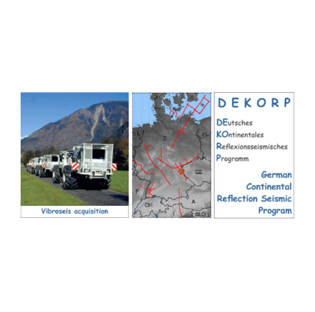
The German Continental Seismic Reflection Program DEKORP (DEutsches KOntinentales Reflexionsseismisches Programm) was carried out between 1984 – 1999 as the German national reflection seismic program funded by the Federal Ministry of Research and Technology (BMFT), Bonn. DEKORP was administrated by the former Geological Survey of Lower Saxony (NLfB), Hannover [now: the State Authority for Mining, Energy and Geology (LBEG)]. In 1994 the DEKORP management was taken over by the Helmholtz Centre Potsdam GFZ German Research Centre for Geosciences.
The aim of DEKORP was to investigate the deep crustal structure of Germany with high-resolution near-vertical incidence (mostly vibro)seismic acquisition, supplemented by wide-angle seismic and other target-oriented piggy-back experiments, all complemented by optimized methods of data processing and interpretation. The DEKORP project was closely linked with the KTB (German continental deep-drilling program) and was an equivalent to many other deep-seismic programs world-wide such as COCORP, BIRPS, LITHOPROBE, ECORS, CROP, BELCORP, IBERSEIS and many more. The DEKORP-Atlas (Meissner & Bortfeld, 1990) gives a detailed overview about most of the different campaigns and results.
In sum, the resulting DEKORP database includes approximately 40 crustal-scale 2D-seismic reflection lines covering a total of ca. 4 700 km and one 3D-seismic reflection survey covering ca. 400 km². Each DEKORP survey is provided with all datasets that are necessary for either a re-processing (i.e. raw unstacked field records in SEGY) or a re-interpretation (i.e. finally processed sections in SEGY or PNG). The raw data are sorted by records or by CDPs. The final data are available as unmigrated or migrated stacks without or with coherency enhancement. Automatical line-drawings are also included. All data come with additional meta information for each domain (source, receiver, CDP) like coordinates, elevations, locations and static corrections combined in ASCII-tables for geometry assignment. Furthermore, all metadata originating from paper copies are made available as scanned files in PNG or PDF, e.g. field and observer reports, location maps in different scales, near-surface profile headers and others.
The DEKORP datasets provide unique and deep insights into the subsurface below Germany covering the earth’s crust from the surface to the upper mantle and are increasingly requested by academic institutions and commercial companies. Fields of applications are geothermal development, hazard analysis, hydrocarbon/shale gas exploration, underground gas storage, tunnel construction and much more.
The Environmental Mapping and Analysis Program (EnMAP) is a German hyperspectral satellite mission that aims at monitoring and characterizing the Earth’s environment on a global scale. EnMAP serves to measure and model key dynamic processes of the Earth’s ecosystems by extract-ing geochemical, biochemical and biophysical parameters, which provide information on the status and evolution of various terrestrial and aquatic ecosystems. In the frame of the EnMAP preparatory phase, pre-flight campaigns including airborne and in-situ measurements in different environments and for several application fields are being conducted. The main purpose of these campaigns is to support the development of scientific applications for EnMAP. In addition, the acquired data are input in the EnMAP end-to-end simulation tool (EeteS) and are employed to test data pre-processing and calibration-validation methods. The campaign data are made freely available to the scientific community under a Creative Commons Attribution 4.0 International License. An overview of all available data is provided in in the EnMAP Flight Campaigns Metadata Portal.
The DFG-funded Specialised Information Service for Geoscience FID GEO (Fachinformationsdienst Geowissenschaften), aims at (1) reducing structural deficits in the area of electronic information and (2) promoting Open Science throughout the research life cycle. The service is hosted at the Göttingen State and University Library in Lower Saxony (SUB Göttingen) and the GFZ German Research Centre for Geosciences in Potsdam. The FID GEO team is made up of highly connected librarians, data publishing professionals, and geoscientists. Over the past five years, FID GEO has become a key player for the promotion of Open Science in the geosciences and occupies a central position for connecting researchers, data repositories, information infrastructures, German geosciences societies and publishers. FID GEO actively offers data and text publication services via their associated repositories GFZ Data Services and GEO-LEOe-docs as well as digitisation on demand of print-only geoscience literature and maps.
GEOFON operates the GFZ Seismological Data Archive, which facilitates access to data from the GEOFON stations, from passive experiments of the Geophysical Instrument Pool Potsdam (GIPP) and those from plate boundary observatories (e.g. IPOC, GONAF, DESERVE, GCO), as well as from many partner networks/institutions providing a permanent and secure archive. All waveform data and metadata are provided in standard seismological data formats using standard services alongside with additional meta information about the data, currently more than 100 seismic networks are distributed to thousands of users through the GFZ access point as well as form federated archives at European and Global level. The data accessible here are seismic networks that are assigned with digital object identifier (DOI) and archived in the GFZ Seismological Data Archive (see also Evans et al., 2015).
The Helmholtz Centre Potsdam GFZ German Research Centre for Geosciences is the “national lab” for Earth Sciences in Germany and part of the Helmholtz Association of non-university research centres. Its main focus is to study the history of the Earth and its characteristics, the processes occurring on its surface and within its interior, as well as the interactions between the geosphere, the hydrosphere, the atmosphere and the biosphere. This datacentre is the main organisational place for data publications from GFZ researchers if they are not related to other datacentres.
The Geophysical Instrument Pool Potsdam (GIPP) provides field instruments for (temporary) seismological studies (both controlled source and earthquake seismology) and for magnetotelluric (electromagnetic) experiments. The GIPP is operated by the GFZ German Research Centre for Geosciences. The instrument facility is open for academic use. Instrument applications are evaluated and ranked by an external steering board. See Haberland and Ritter (2016) for more information.
The determination of Earth’s global gravity field is one of the main tasks of geodesy: it serves as a reference for geodesy itself and provides essential information about the Earth, its interior and its fluid envelope for all geosciences. Thus, it is important to model the gravity field globally and make the state-of-the-art models available to public as geodetic products. With accurate satellite measurements, it is now possible to map the static gravity field as well as its variations with much higher spatial and temporal resolutions compared to the first of its kinds. The list of such models is continuously growing and requires dedicated maintenance.
The International Centre for Global Earth Models (ICGEM) is one of the five services coordinated by the International Gravity Field Service (IGFS) of the International Association of Geodesy (IAG). The primary objective of the ICGEM service is to collect and archive all existing static and temporal global gravity field models and provide an online interactive calculation service for the computation of gravity field functionals freely available to the general public. The calculation of the different functionals of the geopotential (e.g. geoid, gravity anomaly, gravity disturbance, equivalent water height) from a defined global model, on a specified grid or points with respect to a defined reference system, is not trivial for science and scientists and is a responsibility of geodesy too. Additionally, it is important to visualize the spatial and temporal distribution of the global gravity field and therefore interactive visualization is also provided by ICGEM.
Read more about ICGEM in the article published in Earth System Science Data (ESSD, Ince et al., 2019).
IGETS is the International Geodynamics and Earth Tide Service of the International Association of Geodesy (IAG). The main objective of IGETS is to monitor temporal variations of the Earth gravity field through long‐term records from ground gravimeters, tiltmeters, strainmeters and other geodynamic sensors.
IGETS continues the activities of the Global Geodynamics Project (GGP) to provide support to geodetic and geophysical research activities using superconducting gravimeter (SG) data within the context of an international network. Furthermore, IGETS continues the activities of the International Center for Earth Tides (ICET), in particular, in collecting, archiving and distributing Earth tide records from long series of gravimeters, tiltmeters, strainmeters and other geodynamic sensors.
GFZ operates the IGETS data base of worldwide high precision SG records (see also Voigt et al., 2016). The hosted products are:
- Raw gravity and local pressure records sampled at 1 or 2 seconds, in addition to the same records decimated at 1‐minute samples (Level 1 products).
- Gravity and pressure data corrected for instrumental perturbations, ready for tidal analysis. This product is derived from the previous datasets, and is computed by one or several Analysis Centers (Level 2 products).
- Gravity residuals after particular geophysical corrections (including solid Earth tides, polar motion, tidal and non‐tidal loading effects). This product is also derived from the previous dataset and is computed by one or several Analysis Centers (Level 3 products)
The International Real-time Magnetic Observatory Network (INTERMAGNET) is the global network of observatories, monitoring the Earth's magnetic field. The INTERMAGNET programme exists to establish a global network of cooperating digital magnetic observatories, adopting modern standard specifications for measuring and recording equipment, in order to facilitate data exchange and the production of geomagnetic products in close to real time. INTERMAGNET also coordinates the publication of quality-controlled, definitive geomagnetic data from its affiliated observatories.
The online service portal of the Information System and Data Center for geoscientific data (ISDC) is an access point for diverse geoscientific geodata, its corresponding metadata, scientific documentation and software tools. The majority of the data and information, the portal currently offers to the public, are global geomonitoring products such as satellite orbit and Earth gravity field related data as well as geomagnetic and atmospheric data for the exploration. Furthermore, Global Gravity Field models and Earth System Modelling Data are accessible. The ISDC portal's design and the operation is a project of the ISDC-team within the GFZ's Data Center. GFZ Data Services is the partner repository for DOI assignment.
The International Service for the Geoid (ISG) provides free access to a dedicated and comprehensive repository of geoid models through its website. In the archive, both the latest releases of the most important and well-known geoid models, as well as less recent or less known ones, are freely available, giving to the users a wide range of possible applications to perform analyses on the evolution of the geoid computation research field. The ISG is an official service of the International Association of Geodesy (IAG), under the umbrella of the International Gravity Field Service (IGFS). Its main tasks are collecting, analysing, and redistributing local, regional, and continental geoid models and providing technical support to people involved in geoid-related topics for both educational and research purposes. In the framework of its activities, the ISG performs research taking advantage of its archive and organizes seminars and specific training courses on geoid determination, supporting students and researchers in geodesy as well as distributing training material on the use of the most common algorithms for geoid estimation (Reguzzoni et al. 2021).
The KTB (Kontinentales Tiefbohrprogramm der Bundesrepublik Deutschland) was the German Continental Deep Drilling Program with drilling operations from 1989 to 1994. Two boreholes, one 4 and the other 9.1 km deep, served as a telescope into the earth's interior to allow for in-situ observation of physical and chemical processes and calibration of surface experiments.
One of the major goals of the KTB was the elucidation of structure and evolution of the interior zones in a former mountain chain. The drill site near Windischeschenbach, (NE Bavaria, Germany) is at the structural boundary between the Saxothuringian and Moldanubian, two major tectonostratigraphic units of the Hercynian fold belt of the Variscan Orogen in Central Europe. This boundary was regarded as a suture zone formed by the closure of a former oceanic basin c. 320 million years ago. This process gave way to a continent-continent collision and the formation of a mountain chain comparable to the today's extension of the Himalayan mountain chain. Today, the high mountain relief is eroded and, therefore, once deeply buried rocks are exposed at the surface. Therefore, this area is an ideal place for the study of deep-seated crustal processes. Furthermore, detailed geophysical surface experiments during pre-site survey studies revealed that the drill site is characterized by an anomalous high electrical conductivity and pronounced gravimetric and magnetic anomalies at drillable depth of about 10 km.
Key questions to be addressed by continental deep drilling include the evaluation of fundamental processes occurring in the lithosphere, the outer skin of our planet and resource base for mankind. KTB's major research topics were:
- Evaluation of geophysical structures and phenomena
- Investigation of the thermal structure of the continental crust
- In-situ investigation of rock-fluids and their contribution to formation of ore deposits
- Elucidation of structure and evolution of the continental crust
- Determination of the earth's stress field
Furthermore, the establishment of a long-term depth laboratory was an initial goal of the KTB which has been realized by the GFZ – German Research Centre for Geosciences since 1996. The KTB drilling and research activities formed a German key contribution to worldwide efforts on understanding our planet and supported the founding of the International Continental Scientific Drilling Program, ICDP.
Surface and sample investigations have shown that the rock pile drilled is a steeply dipping highly deformed orogenic stack whose major amphibolite facies overprint is of Caledonian age. Late-stage Tertiary faulting created the current block structure while the Hercynian impact such as granitic intrusions is minor. Borehole logging, tests and key experiments have revealed a higher than expected geothermal gradient of 28°/km with about 270°C and close to ductile conditions at 9100 m, a variable and close-to-fail stress regime in accord with models, and a large reservoir of saline deep fluids existing in a fracture-dominated reservoir down to at least 9 km depth.

Advancing the scientific frontier on inter-disciplinary climate impact research for global sustainability and contributing knowledge and solutions for a safe and just climate future – this is the twofold mission of the Potsdam Institute for Climate Impact Research (PIK), a member of the Leibniz Association and a leader in its field. We integrate the latest understanding of the Earth system with the assessment of climate risks, and with the exploration of policies and pathways towards a manageable climate future. A guiding framework for PIK's research is therefore the integration of Planetary Boundaries and Global Commons. The institute in a unique way combines research across disciplines and scales with solution orientation, emphasizing that societal relevance is based on scientific excellence. (from https://www.pik-potsdam.de/en/institute/about)

In recent decades, the risk to society due to natural hazards has increased globally. To counteract this trend, effective risk management is necessary, for which reliable information is essential. Most existing natural hazard and risk information systems address only single components of a complex risk assessment chain, such as, for instance, focusing on specific hazards or simple loss measures. Complex interactions, such as cascading effects, are typically not considered, as well as many of the underlying sources of uncertainty. This can lead to inadequate or even miss-leading risk management strategies, thus hindering efficient prevention and mitigation measures, and ultimately undermining the resilience of societies. Therefore, experts from different disciplines work together in the joint projectRIESGOS 2.0 (Scenario-based multi-risk assessment in the Andes region) and develop innovative scientific methods for the evaluation of complex multi-risk situations with the aim to transfer the results as web services into a demonstrator for a multi-risk information system.
Projects in the International Scientific Continental Drilling Program (ICDP) produce large amounts of data. Since the start of ICDP, data sharing has played an important part in ICDP projects, and the ICDP Operational Support Group, which provides the infrastructure for data capturing for many ICDP projects, has facilitated dissemination of data within project groups. With online Scientific Drilling Database (SDDB), ICDP and the GFZ German Research Centre for Geosciences in Potsdam, Germany created a platform for the public dissemination of drilling data that is now included in GFZ Data Services.
The DFG Priority Program 1803 "EarthShape - Earth Surface Shaping by Biota" (2016-2022) explored between scientific disciplines and includes geoscientists and biologists to study from different viewpoints the complex question how microorganisms, animals, and plants influence the shape and development of the Earth’s surface over time scales from the present-day to the young geologic past. All study sites are located in the north-to-south trending Coastal Cordillera mountains of Chile, South America. These sites span from the Atacama Desert in the north to the Araucaria forests approximately 1300 km to the south. The site selection contains a large ecological and climate gradient ranging from very dry to humid climate conditions.
The TERENO (TERrestrial ENvironmental Observatories) is an initiative of the Helmholtz Centers (Forschungszentrum Jülich – FZJ, Helmholtz Centre for Environmental Research – UFZ, Karlsruhe Institute of Technology – KIT, Helmholtz Zentrum München - German Center for Environmental Health – HMGU, German Research Centre for Geosciences - GFZ, and German Aerospace Center – DLR) TERENO spans an Earth observation network across Germany that extends from the North German lowlands to the Bavarian Alps. This unique large-scale project aims to catalogue the longterm ecological, social and economic impact of global change at regional level.
TERENO datasets published via GFZ Data Services are mainly from the Demmin test site (TERENO-NE). The DEMMIN test site is located within the central monitoring sites of the TERENO Northeastern German Lowland Observatory. It covers 900 km² and exhibits mostly glacial formed lowlands with terminal moraines in the southern part, containing the highest elevation of 83m a.s.l. The region between the rivers Tollense and Peene consists of flat ground moraines, whereas undulating ground moraines determine the landscape character north of the river Peene. The lowest elevation is located near the town Loitz with 0.5m a.s.l. The region is characterized by intense agricultural use and the three rivers Tollense and Trebel which confluence into the Peene River at the Hanseatic city Demmin. The present climate is characterized by a long-term (1981–2010) mean temperature of 8.7 °C and mean precipitation of 584 mm/year, measured at the Teterow weather station by Deutscher Wetterdienst (DWD). The Northeastern German Lowland Observatory is situated in a region shaped by recurring glacial and periglacial processes since at least half a million years. Within this period, three major glaciations covered the entire region, the last time this happened approximately 25-15 ka ago (Weichselian glaciation). Since that time, a young morainic landscape developed characterized by many lakes and river systems that are connected to the shallow ground water table.
The test site is instrumented with more than 40 environmental measurement stations (DLR, GFZ) and 63 soil moisture stations (GFZ). A lysimeter-hexagon (DLR, FZJ) was installed near to the village Rustow and is part of the SOILCan project. A crane completes the measurement infrastructure currently available in the test site installed by GFZ/ DLR in 2011. DOIs are provided for each station with annual updates as new versions of the DOI.

Transregional Collaborative Research Centre 32 "Patterns in Soil-Vegetation-Atmosphere-Systems: Monitoring, Modelling and Data Assimilation" (2007-2019, funded by the German Research Association DFG):
The soil, vegetation and the lower atmosphere are key compartments of the Earth, where almost all activities of mankind take place. This region is characterized by extremely complex patterns, structures and processes that act at different time and space scales. While the exchange of energy, water and carbon is continuous between the different compartments, the pertinent fluxes are strongly heterogeneous and variable in space and time. Therefore, the quantitative prediction of the systems behaviour constitutes a major challenge to scientists and policymakers, especially in view of global climate change.
Traditionally, the scientific disciplines, such as geophysics, soil and plant science, hydrology and meteorology have focused with success on their respective compartments. The interaction of different compartments, however, poses many open questions which are the research topic of this initiative. We are interested in the specific role of patterns and structures of physical and chemical properties and fluxes in the behavior of the soil-plant-atmosphere system at various spatiotemporal scales. We hypothesize that the explicit consideration of patterns and structure will lead to a common methodology that will increase our understanding and predictive capabilities of the soil-vegetation-atmosphere system. Research groups in the field of soil and plant science, remote sensing, hydrology, meteorology and mathematics located at the Universities of Aachen, Bonn, and Cologne and the Research Centre Jülich study the soil-vegetation atmosphere system under this new paradigm.
The TR32DB is the project-database of the Transregional Collaborative Research Centre 32. The database is able to archive and provide all research data that is created by the project participants. This includes measured/modeled data, reports, presentations, publications, and pictures. In addition, purchased geodata is available for the project participants. All data is provided with corresponding metadata. Depending on the respective rights, the download access may be restricted.
„Future rural Africa“ is the interdisciplinary Transregional Collaborative Research Centre 228 funded by the German Research Association (DFG) involving geographers, anthropologists, political scientists, agro-economists, soil scientists and ecologists from the Universities of Bonn and Cologne as well as external partners to address large-scale land use change and related social-ecological transformations along growth corridors in Eastern and Southern Africa.
The TRR228DB is the project-database of the Transregional Collaborative Research Centre 228. The database is able to archive and provide all research data that are created by the project participants. This includes measured/modeled data, reports, presentations, publications, and pictures. In addition, purchased geodata is available for the project participants. All data is provided with corresponding metadata. Depending on the respective rights, the download access may be restricted.
The World Stress Map (WSM) is a global compilation of information on the crustal present-day stress field maintained since 2009 at the Helmholtz Centre Potsdam GFZ German Research Centre for Geosciences within Section 2.6 Seismic Hazard and Stress Field. It is a collaborative project between academia and industry that aims to characterize the crustal stress pattern and to understand the stress sources. The WSM commenced in 1986 as a project of the International Lithosphere Program (ILP) under the leadership of Mary-Lou Zoback. From 1995-2008 it was a project of the Heidelberg Academy of Sciences and Humanities headed by Karl Fuchs and Friedemann Wenzel. Since 2012 the WSM is a member of the ICSU World Data System.
All stress information is analysed and compiled in a standardized format and quality-ranked for reliability and comparability on a global scale. The current new WSM database release 2016 contains 42,870 data records within the upper 40 km of the Earth’s crust) which is almost twice the amount with respect to the previous WSM database release 2008. An increasing number of software tools support the WSM Service.